


 인쇄
인쇄


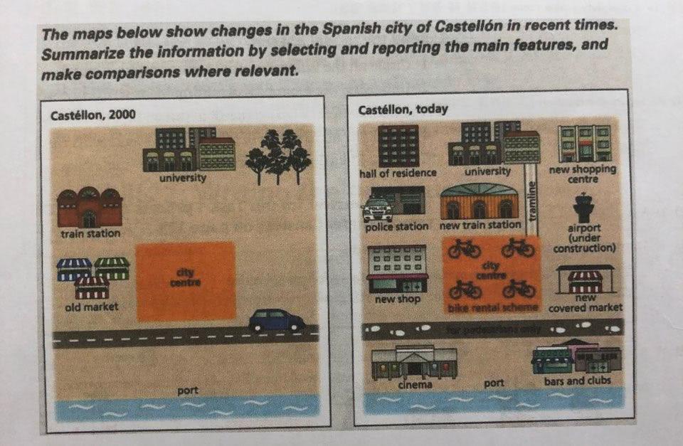 The provided maps illustrate the development in the Spanish city of Castellon in the period from 2000 onwards.
It is generally noticed that there have been significant changes in Castellon over the period shown.
In detail, only the university at the top of the city secured the location although there was a dramatic change in the city.There was nothing in the north west in the city, since the residencial area was built by the goverment . There were trees right next to the university, however, it have been clearned and a new shopping centre is set up curently. Under neath the shopping centre an airport is under construction. The train station which was situated in the west of the city has been relocated to the heart of the city and also was renovated over the period. Also, the tramline has been built , running from the university to the city centre. Moreover, the city centre made a scheme where people can rent bikes from there. Lastly,The old market to the west of the citiy centre has been renovated and locates at the far east end today.
As far as the south of the city centre also has been developed, the vehicle road was converted into a crossroad over the development. Right above the coast, a cinema and bars an clubs have been constructed after the development.
body1에 내용이 너무 쏠려 있는데 지도를 어떻게 분석 해야 될지 모르겠어요ㅜㅜ
과거와 현재를 나타내는 지도가 나오면 시제를 어떻게 써야하나요..!

 댓글 0개
댓글 0개


 불편사항 신고